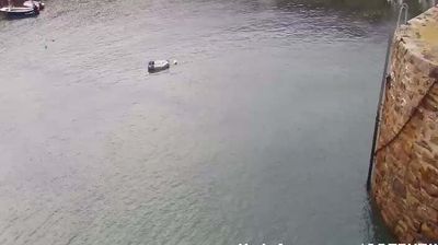
Forest: Aiglle Flight Support
![]() Forest, Γκέρνσι
Forest, Γκέρνσι
Real-Time Environment
Welcome to the live streaming webcam for Forest: Aiglle Flight Support, perfectly situated in the vibrant region of Forest, Γκέρνσι. Watching this live camera allows you to instantly experience the local atmosphere and monitor current climate conditions.

About Forest
A forest is an ecosystem characterized by a dense community of trees. Hundreds of definitions of forest are used throughout the world, incorporating factors such as tree density, tree height, land use, legal standing, and ecological function. The United Nations' Food and Agriculture Organization (FAO) defines a forest as, "Land spanning more than 0.5 hectares with trees higher than 5 meters and a canopy cover of more than 10 percent, or trees able to reach these thresholds in situ. It does not include land that is predominantly under agricultural or urban use." Using this definition, Global Forest Resources Assessment 2025 found that forests covered 4.14 billion hectares, or approximately 31 percent of the world's land area in 2025.
📖 Read more on Wikipedia📍 Location Facts
-
Country
 Γκέρνσι
- Region Γουερνισία
- City Forest
- Coordinates 49.4336°N, -2.5929°E
Have you been to Forest?
Help the community! Share your experience, tell us about the weather, or upload your own photos from this exact location.